|
Axis Introduces Interactive Camera Visualization Tool for SketchUp 3D CAD
Software to Depict Real World Surveillance System Coverage in Building Design
Plans
SketchUp users can select different Axis network cameras and
place into design plans to conceptualize installation and visually depict camera
field of views; Different mounting positions and view angles can be evaluated,
and users can pan, tilt and zoom cameras to determine best video surveillance
coverage
 CHELMSFORD,
Mass. – February 25, 2014 –
Axis Communications, the world leader in network
video, today introduces the Axis Camera Extension for SketchUp 3D CAD software
providing interactive 3D models of Axis Network Cameras to aid in the planning
and design of video surveillance systems. Users can conveniently select and
place Axis cameras directly into CAD building plans to visually depict the areas
the cameras will cover once installed. CHELMSFORD,
Mass. – February 25, 2014 –
Axis Communications, the world leader in network
video, today introduces the Axis Camera Extension for SketchUp 3D CAD software
providing interactive 3D models of Axis Network Cameras to aid in the planning
and design of video surveillance systems. Users can conveniently select and
place Axis cameras directly into CAD building plans to visually depict the areas
the cameras will cover once installed.
 The new SketchUp extension from Axis, which is
free to download, allows users to
see exactly how the cameras fit into the building’s layout and easily spot if
camera views are obstructed by columns or walls. Different mounting positions
and viewing angles can be evaluated through interactive camera models showing
the respective camera coverage areas. This effectively reduces the risk of
unexpected blind spots when planning and designing surveillance systems. The new SketchUp extension from Axis, which is
free to download, allows users to
see exactly how the cameras fit into the building’s layout and easily spot if
camera views are obstructed by columns or walls. Different mounting positions
and viewing angles can be evaluated through interactive camera models showing
the respective camera coverage areas. This effectively reduces the risk of
unexpected blind spots when planning and designing surveillance systems.
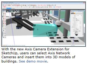
SketchUp users can select Axis Network Cameras from the toolbar to compare and
evaluate different camera models and determine optimal mounting positions. Users
can also pan, tilt and zoom to adjust field of views and define the best
settings for optimal surveillance coverage. See the demo movie
here.
SketchUp 3D CAD software also integrates with Google Maps, which makes it easier
for integrators, architects and engineers to design surveillance systems for
city surveillance or critical infrastructure projects.
“Our team continues to produce an increasing number of tools to make
surveillance system design straightforward and more accurate for our
A&E
community and integrator partners,” said
Geoffrey Bauer, A&E Program Manager for
North America. “We’re excited to add the extremely popular and easy-to-use SketchUp for 3D camera design to our existing portfolio of CAD drawings, which
includes Axis Coverage Shapes for Visio and Axis Camera Families for Autodesk
Revit. SketchUp helps users select the right camera model, installation position
and individual field of view in a virtualized 3D model based on the client’s
building design. Providing this visual surveillance design tool further engages
the customer in the design process to align their expectations more closely with
a realistic solution.”
Axis’ broad portfolio of video surveillance system design tools also includes
Axis Coverage Shapes for Microsoft Visio and
Axis Camera Families for Autodesk Revit.
The Axis Camera Extension for SketchUp is available today and can be downloaded
free of charge from
axis.com/tools. The Axis Camera Extension for SketchUp is
initially available in English, and more languages (French, Italian, German,
Spanish, Russian, Japanese, Korean, Brazilian Portuguese and Chinese) will be
added in Q2, 2014.
|